Global fishing footprint study presents artificial results

After tracking the satellite messages transmitting the position of 70.000 fishing vessels for the past 4 years, a group of researches [1] claim that commercial fishing covers over 55% of the ocean's surface. As a result, their study states that the area fished is four times bigger than the area occupied by agriculture in terms of square kilometres. Europêche argues that the study does not provide any new insight since fishing vessel monitoring systems have been widely implemented and enforced across the oceans for decades showing the exact location of our vessels to the competent authorities. In addition, the report is based on scientifically unsound data, overestimates the proportion of the seabed where fishing occurs and has little use for fisheries management.
The automatic identification system (AIS) is a tracking system used on ships to provide information on the vessel’s position, course and speed. Its main purpose is to avoid collision between vessels from all sectors and not to control fisheries nor assess its footprint. The leading research organisation, Global Fishing Watch, has been analyzing the data collected from, as they say, “known or possible commercial fishing vessels” based on changes in vessel speed and direction. However the organisation acknowledges in their website[2] that the system “may show apparent fishing activity where fishing is not actually taking place” and for that reason included the following liability disclaimer: “Any/all Global Fishing Watch information about apparent fishing activity should be considered an estimate and must be relied upon at my own risk (the database user).”
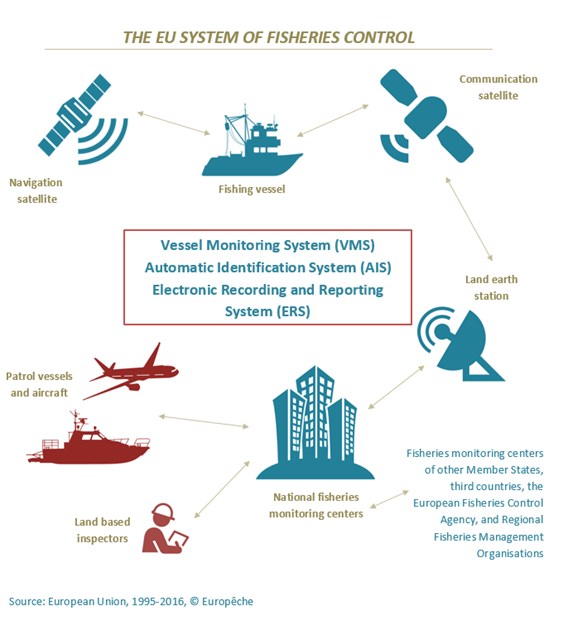
Javier Garat, President of Europêche declared: “It is appalling to see how an organisation using non-reliable data is allowed to publish a study based on estimates and assumptions in a scientific journal. AIS is a tool for safety purposes, never designed to be a policing or scientific tool since it is not encrypted and it can be easily altered. Apart from AIS, the EU fishing fleets are equipped with secure and effective monitoring, control and surveillance systems thoroughly checked by the competent authorities to track all fishing vessels’ activities.”
According to the abstract of the study, industrial fishing occurs in over 55% of the ocean. The immediate conclusion is that fishing vessels operate everywhere and infers that the industry is putting more pressure on fish populations. Europêche argues that the tuna fisheries in the high seas constitute the majority of the “footprint”, which have been monitored and controlled for decades by Regional Fisheries Management Organisations (RFMOs). Tuna is a highly migratory species and therefore fishing vessels spend many days chasing the fish across the oceans without deploying the fishing gear. However, the study considers this as fishing, enlarging the surface to their convenience. Furthermore, this type of fishing has very little impact on the marine environment. For most of the areas, fish stocks are in fact performing well since 78% of the tuna global catch comes from healthy stocks, and this fishery is well documented and globally stable.
Europêche stresses that the global fishing footprint cannot be compared to agriculture, as the latter totally eradicates the natural ecosystem by transforming it and eliminating the native flora and fauna. Tuna fishing has no impact on the marine seabed and solely affects the top predators’ abundance which recovers over time. Therefore, compared to other animal protein, wild-caught fish has a significantly lower carbon footprint due to the fact that it does not need to be artificially fed nor does it require the use of water supply.
Concerning the footprint of bottom trawlers, it has been mapped in much higher resolution already in many parts of the world thanks to the commitment of the fishing industry and, according to the University of Washington fisheries researcher Ray Hilborn, the report overestimates the proportion of the seabed impacted by trawls by 10 fold.
The study finds that large regions of the ocean are not heavily fished, and these areas may offer opportunities for low-cost marine conservation. Europêche claims that apart from the fact that it is quite alarming that a scientific paper formulates controversial policy actions at global level; closing an area to fishing must be based on a scientific recommendation plus a previous impact assessment on a case by case basis and not because it is cheaper. In addition, it should bring a tangible benefit for nature compared with the previous situation.
Javier Garat concluded: “This type of studies, far from providing objective and scientific information, only serve to confuse and deceive public opinion, and obey other interests distant from sustainability and good governance of the fishing activity. The reports fails to reflect that the EU fishing fleets comply with the highest labour, training, safety, environmental and hygiene standards and are well-monitored by the use of several modern electronic and satellite systems. It is therefore clear that the footprint of a European vessel cannot be compared with that of an Asian fishing vessel, as the study portrays.”

Ends
Europêche represents the fisheries sector in Europe. Currently, the Association comprises 10 national organisations of fishing enterprises from the following 8 EU Member States: DE, ES, FR, IT, MT, NL, LV, PL.
Press contacts: Daniel Voces, Managing Director of Europêche: +32.2.230.48.48 daniel.voces@europeche.org
[1] Namely, the collaboration between researchers from the Global Fishing Watch, the National Geographic Society's Pristine seas project, University of California Santa Barbara, Dalhousie University, SkyTruth, Google, and Stanford University.
[2] https://globalfishingwatch.force.com/gfw/GFWRegistration?startUrl=/gfw/s/data-download
Sources: Europeche
Attachments:
Tags: footprint, fisheries, control, Monitoring, AIS, VMS, logbook, Global Fishing Watch, RFMO